Tour du Mont Viso
Four days around the pyramid at the source of the Po
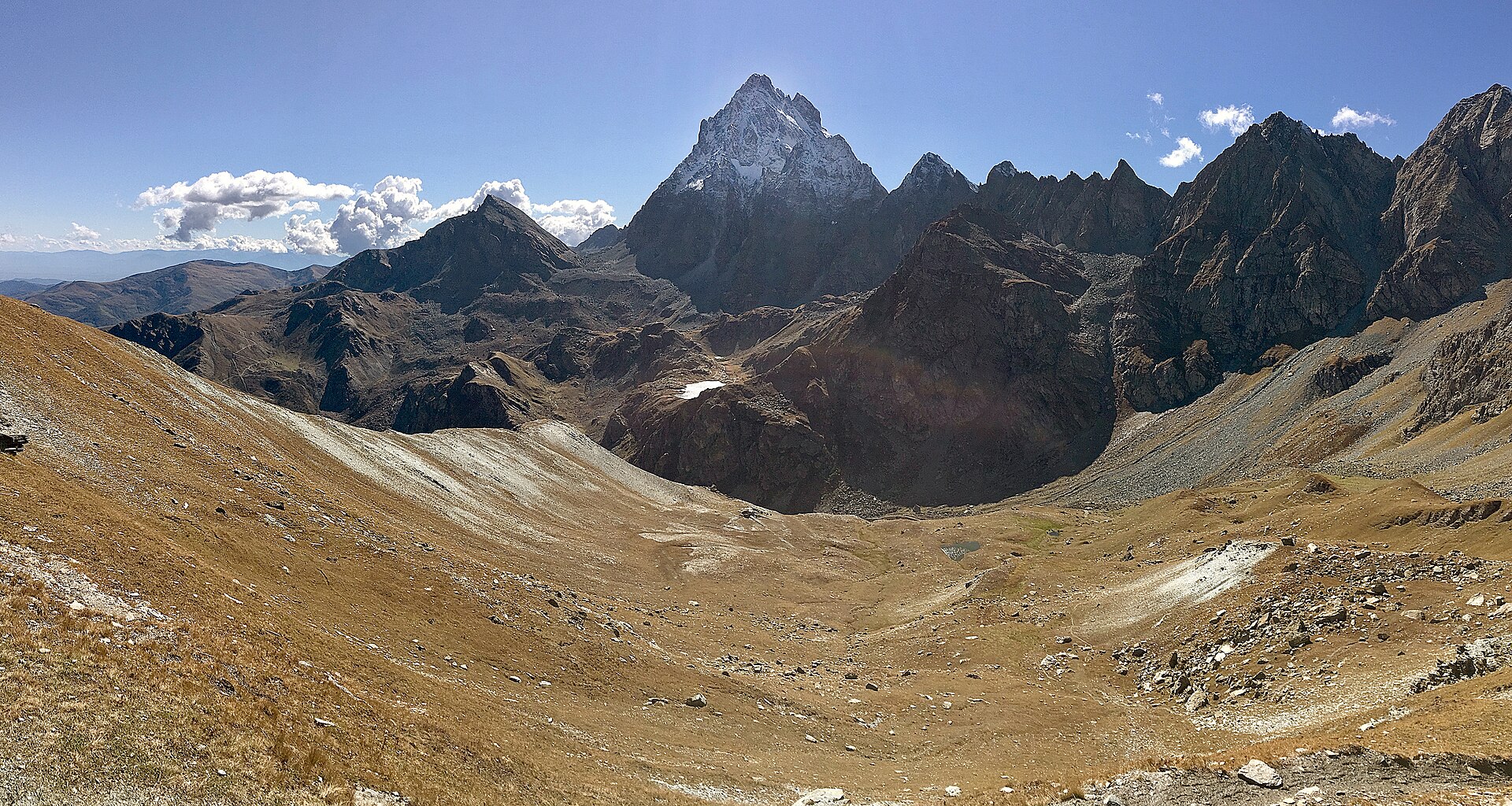
Monviso stands alone: a 3,841 m pyramid visible from Turin and Milan, with the source of the Po at its foot. The tour circles it in four short, high stages between French and Italian refuges, crossing passes above 2,700 m on every one of them.
43 km · 2,900 m ascent · 4 stages · 3–4 days · T3 · France, Italy
About the Tour du Mont Viso
The circuit starts from the Roche Écroulée in the upper Guil, crosses into Italy over the Col de la Traversette, works around the north and east sides of the mountain past the Quintino Sella hut, and returns to France over the Col de Valante. Four stages, four cols, and the mountain in view from almost every one.
It is short but not easy. The record grades it T3, and every stage crosses ground above 2,700 m where snow lingers into July. The stages themselves are unequal: the first and last are half days, the middle two are long.
The Buco del Viso under the Col de la Traversette is the oldest tunnel in the Alps, cut in 1480 to carry salt between Provence and Piedmont. When it is clear of snow it saves the exposed Italian side of the col — take a head torch.
The refuges — Viso, Quintino Sella, Vallante and Giacoletti — are comfortable, well fed and busy in August. Book them: there is nothing else on the circuit.
The 4 classic stages
Stage 1: Roche Écroulée to Refuge du Viso
Roche Écroulée to Refuge du Viso · 7 km · 640 m ascent · 0 m descent · T3
A short opening stage up the Guil from the road head, past the Viso belvedere, then a rising traverse to the refuge below the Col de la Traversette.
Stage 2: Refuge du Viso to Quintino Sella
Refuge du Viso to Rifugio Quintino Sella · 12.8 km · 1,080 m ascent · 960 m descent · T3
Over the Col de la Traversette — or through the Buco del Viso beneath it — down towards Pian del Re, then up past the Lago Superiore to the Quintino Sella hut under the north face.
Stage 3: Quintino Sella to Refuge Vallante
Rifugio Quintino Sella to Refuge Vallante · 12.4 km · 720 m ascent · 900 m descent · T3
The long Italian traverse under the east and south faces, over the Passo Gallarino and the Passo San Chiaffredo, then back across the border ridge at the Col de Valante.
Stage 4: Refuge Vallante to Roche Écroulée
Refuge Vallante to Roche Écroulée · 11.2 km · 410 m ascent · 1,090 m descent · T3
The closing descent down the Vallante valley to the Guil, with Monviso behind you and the road head reached by early afternoon.
Refuges, gîtes and huts on the circuit
- km 7.0 — Refuge du Viso, 2,460 m, 65 beds (stage 1)
- km 13.3 — Refuge Giacoletti, 2,741 m (stage 2)
- km 14.1 — Rifugio Albergo Alpino "Pian del Re", 2,020 m (stage 2)
- km 19.8 — Refuge Quintino Sella al Lago Grande del Viso, 2,640 m, 113 beds (stage 2)
- km 30.0 — Bivouac Berardo, 2,710 m (stage 3)
- km 32.4 — Refuge Vallante, 2,435 m, 60 beds (stage 3)
Cols on the classic line
- Col de la Traversette — 2,947 m (stage 2)
- Passo Luisas — 3,019 m (stage 2)
- Col du Viso — 2,650 m (stage 2)
- Pas des Sagnettes — 2,990 m (stage 3)
- Passo Gallarino — 2,727 m (stage 3)
- Passo San Chiaffredo — 2,764 m (stage 3)
- Col de Valante — 2,815 m (stage 4)
- Passo Giacoletti — 2,990 m (stage 4)
Know before you go
- July to September. Several of the cols hold snow well into the summer, and early-season crossings can want an axe.
- The stages are deliberately unequal — strong parties combine stages 1 and 2, or 3 and 4, and walk the tour in three days.
- All four refuges take reservations and are the only accommodation on the loop; the Italian side fills first in August.
- The Buco del Viso tunnel is 75 m long and unlit. Check whether it is open before relying on it and carry a head torch.
- This is a border route: bring a card that works in both countries and note that Italian refuges often prefer cash.
- Storms build fast over the pyramid in the afternoon. Cross the cols early.
Frequently asked questions
How long is the Tour du Mont Viso?
About 45 km with roughly 2,900 m of ascent, walked here in four stages. Fit parties link stages and do it in three days; four is the comfortable rhythm the refuges are spaced for.
How hard is the Tour du Monviso?
The record grades it T3 — mountain hiking with some steep and rocky ground. The difficulty is the altitude of the cols rather than any technical section, and snow can linger on them into July.
Where does the Tour du Mont Viso start?
Most walkers start from the Roche Écroulée at the head of the Guil valley above Ristolas in France; the Italian side is usually started from Pian del Re, the source of the Po.
Do you need to book the refuges?
Yes. The Viso, Quintino Sella and Vallante huts are the only accommodation on the circuit and fill up in July and August.
More multi-day routes
- Aiguilles Rouges Circuit — 50 km, 6 stages
- Alta Via 1 — 113 km, 8 stages
- Alta Via 2 — 159 km, 7 stages
- Alta Via dei Silenzi — 180 km, 7 stages
- Grand Tour du Chambeyron — 70 km, 5 stages
- Haute Route Bernoise — 57 km, 4 stages
- Haute Route Chamonix–Zermatt — 210 km, 10 stages
- Sentiero Roma — 40 km, 4 stages
- Tour des Combins — 95 km, 6 stages
- Tour des Écrins — 194 km, 5 stages
- Tour des Glaciers de la Vanoise — 54 km, 6 stages
- Tour du Beaufortain — 94 km, 6 stages
- Tour du Grand Paradis — 150 km, 6 stages
- Tour du Mont Blanc — 155 km, 10 stages
- Tour du Queyras (GR 58) — 104 km, 7 stages
Sources and provenance
Stage metrics, tracks, huts and passes come from the Traverse route database. Conditions change: verify refuge opening, pass conditions and transport before you go.
Page reviewed .