Tour des Combins
A high circuit around the Grand Combin between Switzerland and Italy
The Tour des Combins circles the Grand Combin across the Valais and Aosta borderlands, joining high passes, glacier viewpoints and staffed refuges in a compact international loop.
95 km · 5,517 m ascent · 6 stages · 5–7 days · · Switzerland, Italy
About the Tour des Combins
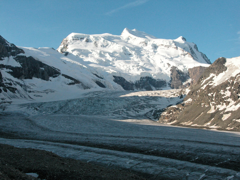
The Tour des Combins loops the Grand Combin between the Swiss Valais and the Italian side, with the massif's glaciers and 4,000-metre skyline visible from a chain of high passes and huts.
The route is shorter than the TMB but feels more remote: several stages stay high, the passes are stony, and the circuit crosses a real national border rather than simply circling a valley. The huts make the logistics possible, but weather and booking still determine the best direction.
Five to seven days is a useful planning range. Strong walkers can keep the classic rhythm; parties carrying more kit or waiting for a pass to clear should leave room for a shorter stage in the Valais or an extra hut night.
A glacier view does not mean the hiking line crosses a glacier. Keep the walker's circuit separate from mountaineering variants, and check the current status of every pass before setting out.
The 6 classic stages
Stage 1: Bourg-Saint-Pierre to Cabane de Mille
Bourg-Saint-Pierre to Cabane de Mille · 16.2 km · 937.89 m ascent · 936.87 m descent
Climb from the Valais village into the first high hut, with the route quickly opening toward the Grand Combin skyline.
Stage 2: Cabane de Mille to Panossière
Cabane de Mille to Cabane de Panossière · 16.2 km · 937.89 m ascent · 936.87 m descent
A high Swiss stage toward the Corbassière glacier and the hut's dramatic balcony beneath the massif.
Stage 3: Panossière to Chanrion
Cabane de Panossière to Cabane de Chanrion · 16.1 km · 937.89 m ascent · 936.87 m descent
Cross the high ground at the heart of the circuit before turning toward the Italian valleys.
Stage 4: Chanrion to Champillon
Cabane de Chanrion to Champillon · 16.2 km · 937.89 m ascent · 936.87 m descent
The route turns around the southern side of the massif, trading glacier views for broad Aosta and Valais valleys.
Stage 5: Champillon to Grand Saint-Bernard
Champillon to Grand Saint-Bernard · 15.2 km · 882.72 m ascent · 881.76 m descent
Follow the border country toward the historic pass and hospice at the western end of the loop.
Stage 6: Grand Saint-Bernard to Bourg-Saint-Pierre
Grand Saint-Bernard to Bourg-Saint-Pierre · 15.2 km · 882.72 m ascent · 881.76 m descent
Close the circuit with the long descent back into the Valais and the original trailhead.
Refuges, gîtes and huts on the circuit
- km 5.4 — Cabane du Plan du Jeu, — (stage 1)
- km 10.9 — Hospice du Grand Saint-Bernard, 2,470 m, 104 beds (stage 1)
- km 31.2 — Rifugio Letey-Champillon, 2,465 m, 32 beds (stage 2)
- km 53.1 — Cabane de Chanrion, 2,462 m, 55 beds (stage 4)
- km 68.4 — Cabane FXB Panossière, 2,641 m, 75 beds (stage 4)
- km 75.1 — Cabane Brunet, 2,104 m, 56 beds (stage 5)
- km 101.2 — Cabane de Mille, 2,473 m, 40 beds (stage 6)
Cols on the classic line
Know before you go
- Mid-June to September is the normal window, with the highest passes often holding snow at the start of summer.
- The route crosses Switzerland and Italy. Plan transport, currency and phone coverage on both sides of the border.
- Refuges are the route's natural stages and should be booked early for July and August.
- The Italian side can feel drier and more exposed than the Swiss valleys. Carry water and do not assume every hut is open.
- Check the Grand Combin weather separately from the valley forecast: the massif creates its own cloud and wind.
Frequently asked questions
How long is the Tour des Combins?
The stored loop is about 95 km with roughly 5,500 m of ascent. Most parties take five to seven days.
Which countries does the Tour des Combins cross?
The circuit crosses Switzerland and Italy around the Grand Combin massif.
How hard is the Tour des Combins?
It is a high alpine hike with repeated passes, stony terrain and changeable weather. The route is non-technical in its walking form but deserves mountain experience.
When should you walk the Tour des Combins?
Mid-June to September is typical, subject to snow, pass conditions and the opening dates of the huts.
More multi-day routes
- Aiguilles Rouges Circuit — 50 km, 6 stages
- Alta Via 1 — 113 km, 8 stages
- Alta Via 2 — 159 km, 7 stages
- Alta Via dei Silenzi — 180 km, 7 stages
- Grand Tour du Chambeyron — 70 km, 5 stages
- Haute Route Bernoise — 57 km, 4 stages
- Haute Route Chamonix–Zermatt — 210 km, 10 stages
- Sentiero Roma — 40 km, 4 stages
- Tour des Écrins — 194 km, 5 stages
- Tour des Glaciers de la Vanoise — 54 km, 6 stages
- Tour du Beaufortain — 94 km, 6 stages
- Tour du Grand Paradis — 150 km, 6 stages
- Tour du Mont Blanc — 155 km, 10 stages
- Tour du Mont Viso — 43 km, 4 stages
- Tour du Queyras (GR 58) — 104 km, 7 stages
Sources and provenance
Stage metrics, tracks, huts and passes come from the Traverse route database. Conditions change: verify refuge opening, pass conditions and transport before you go.
Page reviewed .