Tour des Glaciers de la Vanoise
A high circuit around France's first national park
The Tour des Glaciers de la Vanoise circles the high valleys of the national park, linking refuges, passes and wide glacier views between Pralognan, Aussois and the Tarentaise.
54 km · 2,445 m ascent · 6 stages · 5–8 days · · France
About the Tour des Glaciers de la Vanoise
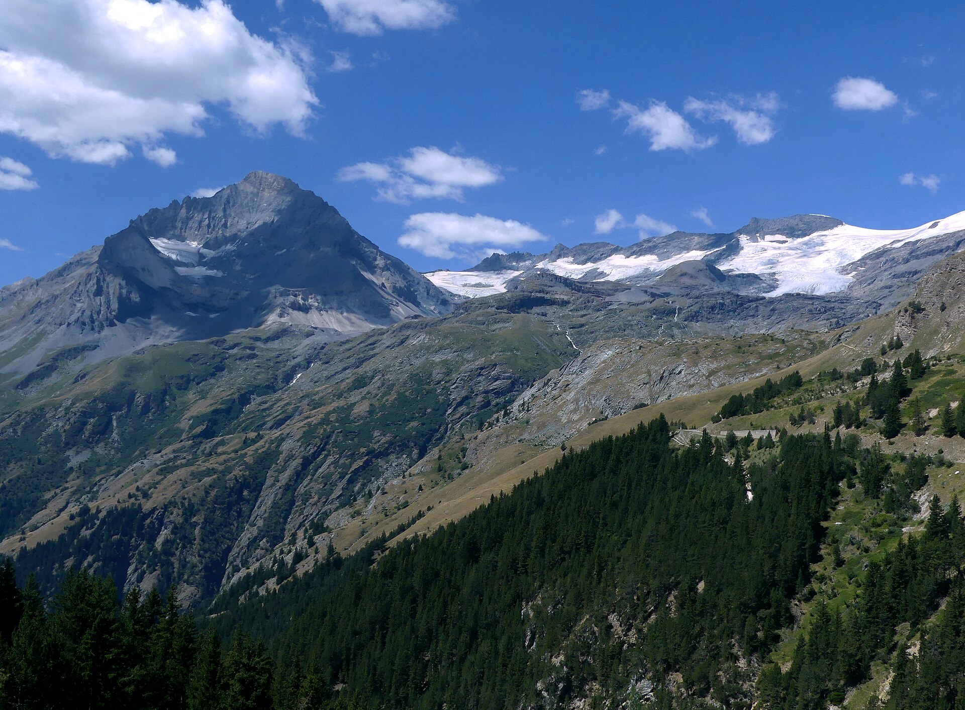
The circuit moves around the Vanoise high country through Pralognan, the Col de la Vanoise, the Dent Parrachée side and the Col de Chavière, with some of the best glacier panoramas in the French Alps.
The route sits in a sweet spot between accessible hut-to-hut walking and real high-mountain terrain. There are no compulsory glacier crossings on the standard circuit, but snow, steep passes and storm exposure still make the day-by-day conditions important.
Most parties take five to eight days. The short distance is deceptive: refuges are separated by high cols and rough paths, and the route repeatedly climbs back above the tree line after each valley turn.
Treat the park as a connected weather system. A blue morning in Pralognan does not remove the need to check the next pass, the refuge opening and the line of retreat.
The 6 classic stages
Stage 1: Pralognan to Col de la Vanoise
Pralognan-la-Vanoise to Col de la Vanoise · 9.2 km · 415.65 m ascent · 590.07 m descent
Climb from the valley into the first high refuge country, with the Grande Casse and its glaciers setting the scale.
Stage 2: Col de la Vanoise to Arpont
Col de la Vanoise to Refuge de l'Arpont · 9.2 km · 415.65 m ascent · 590.07 m descent
Traverse the northern balcony above the Tarentaise, keeping the Vanoise glaciers in view across the valley.
Stage 3: Arpont to Dent Parrachée
Refuge de l'Arpont to Dent Parrachée · 9.2 km · 415.65 m ascent · 590.07 m descent
Turn east into the Aussois side of the park, where high passes and glacier viewpoints break the long traverse.
Stage 4: Dent Parrachée to Péclet-Polset
Dent Parrachée to Refuge de Péclet-Polset · 9.2 km · 415.65 m ascent · 590.07 m descent
Return across the high country toward the southern valleys and the next refuge beneath the glaciers.
Stage 5: Péclet-Polset to Col de Chavière
Refuge de Péclet-Polset to Col de Chavière · 8.6 km · 391.2 m ascent · 555.36 m descent
Climb toward the high closing pass, with rough ground and changing weather at the centre of the day.
Stage 6: Col de Chavière to Pralognan
Col de Chavière to Pralognan-la-Vanoise · 8.6 km · 391.2 m ascent · 555.36 m descent
Drop back into Pralognan and close the Vanoise circuit through the last valley section.
Refuges, gîtes and huts on the circuit
- km 3.1 — Refuge des Barmettes, 2,010 m (stage 1)
- km 7.3 — Refuge du Col de la Vanoise, 2,518 m, 129 beds (stage 1)
- km 17.2 — Refuge de la Leisse, 2,487 m (stage 2)
- km 50.5 — Refuge Le Repoju, — (stage 5)
- km 53.3 — Refuge du Roc de la Pêche, 1,911 m (stage 5)
- km 58.8 — Refuge de Péclet-Polset, 2,479 m, 84 beds (stage 5)
Cols on the classic line
Know before you go
- The high season is usually mid-June to September. Confirm snow on the cols and the operating dates of refuges before leaving.
- The circuit stays near glaciated terrain even when the walking line is non-glacial. Do not add mountaineering variants without the right skills and equipment.
- Refuges can be the only practical overnight option on the high sections. Reserve them before locking in your dates.
- The national park has specific rules for dogs, camping, fires and wildlife. Check the current park guidance.
- Plan an exit for every stage: the road network is close in places, but not always quickly reachable from a high refuge.
Frequently asked questions
How long is the Tour des Glaciers de la Vanoise?
The stored line is about 54 km. Most hikers take five to eight days because the circuit is high and refuge stages are shaped by the passes.
Does the route cross glaciers?
The standard walking circuit is planned as a non-glacial hut-to-hut route, but it stays close to glaciers and can hold snow. Check current conditions before departure.
Where does the Tour des Glaciers de la Vanoise start?
Pralognan-la-Vanoise is a common access point, with other trailheads possible around the park depending on the chosen direction.
When should you walk it?
Mid-June to September is typical, subject to pass conditions, refuge opening dates and the year's snowpack.
More multi-day routes
- Aiguilles Rouges Circuit — 50 km, 6 stages
- Alta Via 1 — 113 km, 8 stages
- Alta Via 2 — 159 km, 7 stages
- Alta Via dei Silenzi — 180 km, 7 stages
- Grand Tour du Chambeyron — 70 km, 5 stages
- Haute Route Bernoise — 57 km, 4 stages
- Haute Route Chamonix–Zermatt — 210 km, 10 stages
- Sentiero Roma — 40 km, 4 stages
- Tour des Combins — 95 km, 6 stages
- Tour des Écrins — 194 km, 5 stages
- Tour du Beaufortain — 94 km, 6 stages
- Tour du Grand Paradis — 150 km, 6 stages
- Tour du Mont Blanc — 155 km, 10 stages
- Tour du Mont Viso — 43 km, 4 stages
- Tour du Queyras (GR 58) — 104 km, 7 stages
Sources and provenance
Stage metrics, tracks, huts and passes come from the Traverse route database. Conditions change: verify refuge opening, pass conditions and transport before you go.
Page reviewed .