Tour du Mont Blanc
The classic circuit of the Mont Blanc massif, across France, Italy and Switzerland
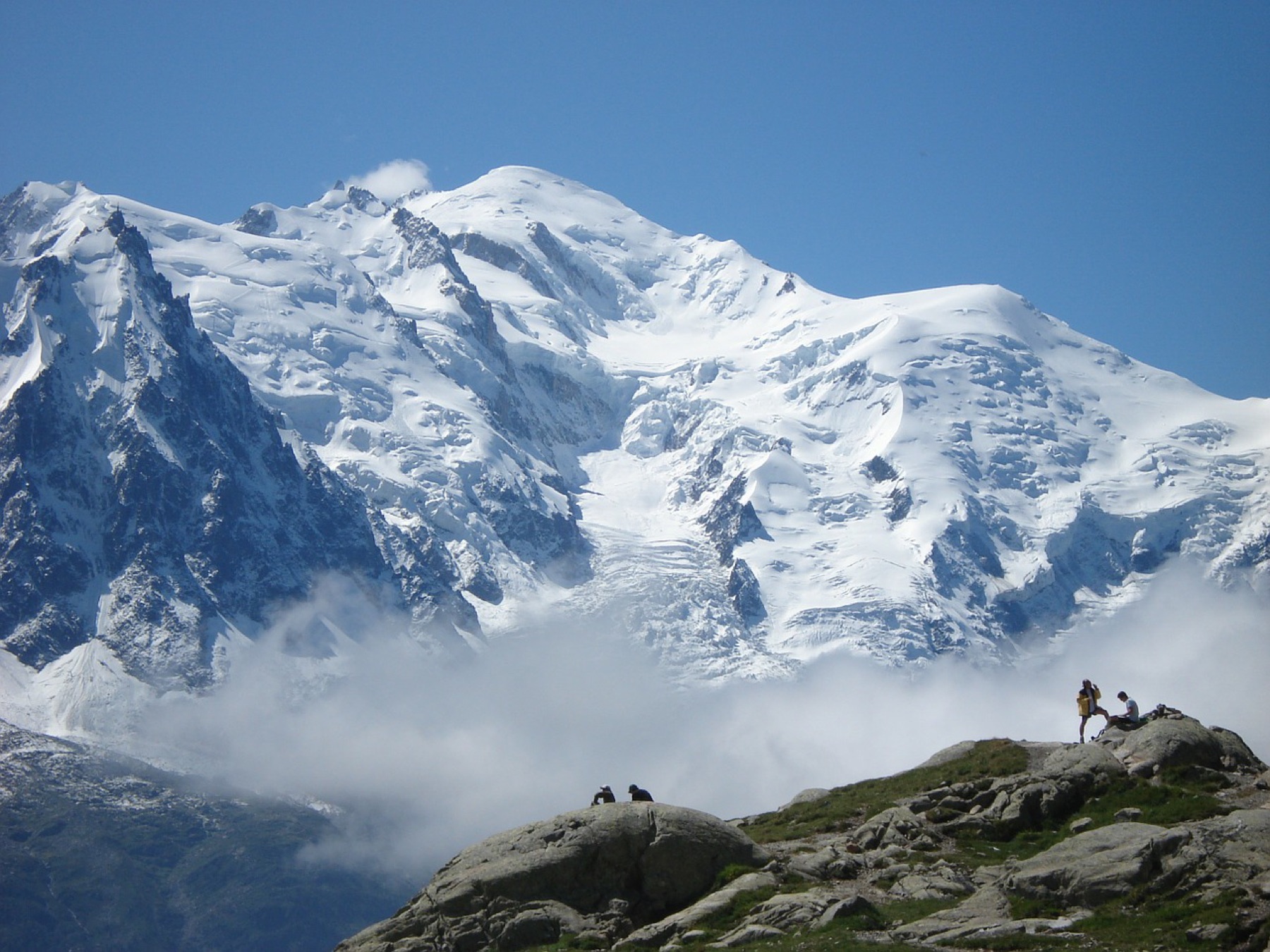
The Tour du Mont Blanc loops the entire Mont Blanc massif in ten classic walking stages, crossing seven major passes and three countries before returning to Les Houches. It is the most walked long-distance route in the Alps — and one of the few where you can sleep in a staffed refuge every single night.
155 km · 8,000 m ascent · 10 stages · 7–11 days · T2 · France, Italy, Switzerland
About the Tour du Mont Blanc
The TMB circles the Mont Blanc massif anticlockwise from Les Houches, through the Val Montjoie, over the Col de la Seigne into Italy, up the Val Ferret into Switzerland, and back to Chamonix over the Aiguilles Rouges balconies. Nothing on the classic line is harder than T2 hiking, but the circuit stacks up roughly 8,000 m of ascent over ten stages.
Most walkers take 7 to 11 days. The ten stages below are the classic refuge-to-refuge splits: they are long enough to keep the circuit to a fortnight of holiday, and short enough that every day ends at a staffed hut, gîte or valley village. Strong parties merge stages 6 and 7 or 9 and 10; parties carrying camping gear usually add a day in the Italian Val Ferret.
The route is walked in both directions and can be started from any of the trailheads it passes — Les Houches, Les Contamines, Courmayeur, La Fouly, Champex, Trient or Chamonix. Anticlockwise is the traditional direction, keeps the Grandes Jorasses in front of you through the Italian Val Ferret, and matches how most refuges book their beds.
Every stage has cable-car, bus or train escapes, so bad weather rarely ends a trip — it re-routes it. That flexibility is what makes the TMB the standard first long-distance route in the Alps, and why the huts fill up months ahead in July and August.
The 10 classic stages
Stage 1: Les Houches to Les Contamines
Les Houches to Les Contamines-Montjoie · 17.9 km · 1,493 m ascent · 1,325 m descent · T2
The circuit opens over the Col de Voza on the flank of the Bionnassay glacier, then works down through Le Champel and La Gruvaz into the Val Montjoie. The Col de Tricot variant turns the same day into a proper mountain crossing.
Stage 2: Les Contamines to Croix du Bonhomme
Les Contamines-Montjoie to Refuge de la Croix du Bonhomme · 9.9 km · 1,300 m ascent · 57 m descent · T2
A single long climb: the Roman road past Notre-Dame de la Gorge, the Nant Borrant and Balme huts, then the open ground to the Col du Bonhomme and the ridge traverse to the refuge at 2,450 m.
Stage 3: Croix du Bonhomme to Val Veny
Refuge de la Croix du Bonhomme to Refuge Elisabetta, Val Veny · 14.1 km · 940 m ascent · 1,140 m descent · T3
The high day and the border crossing: over the Col des Fours, down to the Ville des Glaciers, then up to the Col de la Seigne at 2,516 m for the first full view of the Italian side of Mont Blanc.
Stage 4: Val Veny to Montagne de la Saxe
Refuge Elisabetta to Refuge Bertone · 16.7 km · 1,350 m ascent · 1,550 m descent · T2
Past Lac Combal and over the Col Chécrouit to drop into Courmayeur — the one real town on the circuit — before climbing back out to the Bertone hut on the balcony above the Val Ferret.
Stage 5: Montagne de la Saxe to Val Ferret
Refuge Bertone to Refuge Bonatti or Refuge Elena · 16.6 km · 1,300 m ascent · 1,200 m descent · T2
The Italian balcony traverse, with the Grandes Jorasses opposite the whole way. Over the Tête de la Tronche, the Col Sapin and the Pas Entre-Deux-Sauts to Bonatti, or on to Elena under the Grand Col Ferret.
Stage 6: Italian Val Ferret to Swiss Val Ferret
Refuge Bonatti / Refuge Elena to La Fouly · 11.5 km · 490 m ascent · 950 m descent · T2
The second border: the Grand Col Ferret at 2,537 m, then a long, gentle descent past the alpage de la Peule and Ferret into the Swiss Val Ferret at La Fouly.
Stage 7: La Fouly to Champex
La Fouly to Champex-Lac · 16 km · 960 m ascent · 1,062 m descent · T2
The quietest, lowest stage: down the Swiss Val Ferret through Praz de Fort and Issert, then the climb through forest to the lake at Champex. Two lines are possible — the waymarked village route or the Deuve path from Saleinaz.
Stage 8: Champex to Trient
Champex-Lac to Trient · 15 km · 960 m ascent · 1,130 m descent · T2
The Bovine path over the Alp Bovine and La Giète to the Col de la Forclaz and down to Trient. The alternative — the Fenêtre d'Arpette at 2,665 m — is the hardest sanctioned variant on the circuit.
Stage 9: Trient to Lac Blanc
Trient to Refuge du Lac Blanc · 16.7 km · 1,964 m ascent · 923 m descent · T2
Back into France over Les Tseppes and Catogne, down to Vallorcine and the Col des Montets, then the climb into the Aiguilles Rouges to Lac Blanc — the classic reflection of Mont Blanc, the Verte and the Drus.
Stage 10: Lac Blanc to Les Houches
Refuge du Lac Blanc to Les Houches · 18.4 km · 1,068 m ascent · 2,405 m descent · T2
The closing balcony: La Flégère, Charlanon and Plan Praz, over the Col du Brévent and the Brévent summit at 2,525 m, then the long descent by Bellachat and Merlet back to Les Houches.
Refuges, gîtes and huts on the circuit
- km 4.9 — Refuge du Fioux, 1,670 m, 22 beds (stage 1)
- km 7.9 — Auberge de Bionnassay, — (stage 1)
- km 12.7 — Refuge de Miage, 1,560 m, 47 beds (stage 1)
- km 14.1 — Auberge du Truc, 1,750 m, 28 beds (stage 1)
- km 17.9 — Chalet CAF des Contamines Montjoie, 1,175 m, 20 beds (stage 1)
- km 17.9 — Chalet du CAF Contamines, 1,164 m (stage 1)
- km 22.7 — Refuge du Nant Borrant, 1,470 m, 35 beds (stage 2)
- km 22.7 — Chalet - Refuge de Nant Borrant, — (stage 2)
- km 24.7 — Refuge des Prés, 1,935 m (stage 2)
- km 25.2 — Refuge de la Balme (Contamines), 1,706 m, 40 beds (stage 2)
- km 25.2 — Refuge de la Balme, 1,706 m (stage 2)
- km 30.5 — Refuge du Col de la Croix du Bonhomme, 2,450 m, 115 people beds (stage 2)
- km 37.4 — Refuge des Mottets, 1,864 m, 80 people beds (stage 3)
- km 42.1 — La Casermetta, 2,365 m (stage 3)
- km 44.6 — Refuge Elisabetta Soldini, 2,185 m, 77 people beds (stage 3)
- km 44.6 — Rifugio Elisabetta Soldini Montanaro, 2,194 m, 77 beds (stage 3)
- km 47.5 — Refuge Combal , 1,965 m (stage 4)
- km 54.4 — Refuge Gîte Mont Blanc Cai Uget, 1,666 m (stage 4)
- km 54.4 — Refuge La Maison Vieille, 1,952 m (stage 4)
- km 54.4 — Refuge le Randonneur, 1,900 m (stage 4)
- km 59.9 — Posto Tappa Alessio Allegri, 1,816 m (stage 4)
- km 61.5 — Refuge Bertone, 1,996 m, 65 people beds (stage 5)
- km 61.5 — Rifugio Bertone, — (stage 5)
- km 71.2 — Refuge Bonatti, 2,025 m, 75 people beds (stage 5)
- km 71.2 — Rifugio Walter Bonatti, 2,030 m, 7 beds (stage 5)
- km 75.8 — Chalet Val Ferret, 1,780 m (stage 5)
- km 78.0 — Refuge Elena, 2,062 m, 127 people beds (stage 5)
- km 78.0 — Rifugio Elena, 2,055 m, 127 beds (stage 5)
- km 83.2 — Refuge alpage de la Peule, 2,071 m (stage 6)
- km 87.7 — Gîte de la Léchère, 1,700 m (stage 6)
- km 108.7 — Plan de l'Au, — (stage 8)
- km 120.4 — Refuge Le Peuty, —, 22 beds (stage 8)
- km 137.2 — Refuge du Lac Blanc, 2,350 m, 40 beds (stage 9)
- km 140.2 — La Flégère, — (stage 10)
- km 149.0 — Refuge de Bellachat, 2,152 m, 18 beds (stage 10)
Cols on the classic line
- Col de Voza — 1,655 m (stage 1)
- Col du Bonhomme — 2,329 m (stage 2)
- Col de la Croix du Bonhomme — 2,408 m (stage 2)
- Col des Fours — 2,665 m (stage 3)
- Col de la Seigne — 2,516 m (stage 3)
- Col des Pyramides Calcaires — 2,573 m (stage 3)
- Grand col Ferret — 2,537 m (stage 6)
- Col du Brévent — 2,368 m (stage 10)
Know before you go
- One of the busiest trails in Europe in high summer — September brings thinner crowds and stable weather, with most refuges open until mid-to-late month.
- You are never more than about three hours from food and a bed, so there is no need to carry heavy resupply.
- Refuge availability, not distance, usually decides where a stage ends. Book the Italian Val Ferret huts and Champex first — they are the pinch points.
- Camping self-sufficiently changes the stage splits: the wild-camping rules differ in France, Italy and Switzerland, and bivouac zones are marked locally.
- Trail runners are enough once the snow has gone. In early summer, crampons can still be useful on the névés below the highest cols.
- The high cols — Fours, Seigne, Grand Ferret, Bonhomme — hold snow into early July and are exposed to storms. Check the forecast per pass, not per valley.
Frequently asked questions
How long is the Tour du Mont Blanc?
The classic circuit is about 155 km with roughly 8,000 m of ascent and the same descent, split here into 10 stages. Most walkers complete it in 7 to 11 days depending on how many stages they merge and whether they use lifts or buses.
How hard is the Tour du Mont Blanc?
The classic line is graded T2 — mountain hiking on marked paths, with no glacier travel or scrambling. The difficulty is cumulative: seven passes above 2,300 m and 800 m to 1,900 m of ascent on a typical stage. The Col des Fours and Fenêtre d'Arpette variants are steeper and hold snow longer.
When is the best time to walk the TMB?
Mid-June to late September. Refuges are generally staffed from mid-June to mid-September, high cols can hold snow into early July, and September usually offers the most stable weather with far fewer walkers.
Do you need a guide for the Tour du Mont Blanc?
No. The circuit is waymarked throughout and does not cross glaciated terrain. A guide is worth it if you want the alpine variants, want the logistics handled, or are new to multi-day mountain weather.
Which countries does the Tour du Mont Blanc cross?
France, Italy and Switzerland. The circuit enters Italy over the Col de la Seigne, crosses to Switzerland over the Grand Col Ferret, and returns to France over the Col de Balme or the Col des Montets.
More multi-day routes
- Aiguilles Rouges Circuit — 50 km, 6 stages
- Alta Via 1 — 113 km, 8 stages
- Alta Via 2 — 159 km, 7 stages
- Alta Via dei Silenzi — 180 km, 7 stages
- Grand Tour du Chambeyron — 70 km, 5 stages
- Haute Route Bernoise — 57 km, 4 stages
- Haute Route Chamonix–Zermatt — 210 km, 10 stages
- Sentiero Roma — 40 km, 4 stages
- Tour des Combins — 95 km, 6 stages
- Tour des Écrins — 194 km, 5 stages
- Tour des Glaciers de la Vanoise — 54 km, 6 stages
- Tour du Beaufortain — 94 km, 6 stages
- Tour du Grand Paradis — 150 km, 6 stages
- Tour du Mont Viso — 43 km, 4 stages
- Tour du Queyras (GR 58) — 104 km, 7 stages
Sources and provenance
Stage metrics, tracks, huts and passes come from the Traverse route database. Conditions change: verify refuge opening, pass conditions and transport before you go.
Page reviewed .