Gasherbrum II
Gasherbrum II, originally surveyed as K4, is the 13th highest mountain in the world at 8,035 metres (26,362 ft) above sea level. It is the third-highest peak of the Gasherbrum massif, and is located in the Karakoram, on the border between Gilgit–Baltistan, Pakistan and Xinjiang, China.
- Elevation
- 8,034 m
- Prominence
- 1,524 m
- Coordinates
- 35.75750° N, 76.65278° E
- Range
- Gasherbrum
- Region
- Kashgar Prefecture, Pakistan
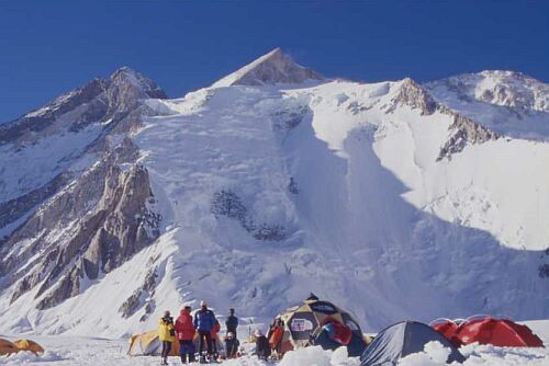
About Gasherbrum II
Gasherbrum II is an 8,035-metre peak of the Baltoro Muztagh in Pakistan’s Karakoram, historically recorded as 26,360 feet in the account of the 1956 Austrian expedition . It is commonly identified as the world’s thirteenth-highest mountain and rises above the South Gasherbrum Glacier, with its normal route following a southwest spur and ridge system .
Open Gasherbrum II in Traverse at 35.75750° N, 76.65278° E to inspect 8,034 m of relief, 1,524 m of prominence, and approaches around Kashgar Prefecture, Pakistan on 3D terrain.
Documented mountaineering milestones
- 1956 — First ascent of Gasherbrum II during the Austrian Karakoram Expedition: Fritz Moravec, Josef “Sepp” Larch, and Hans Willenpart
- 2011 — First winter ascent via the normal route up the southwest ridge: Simone Moro, Cory Richards, and Denis Urubko
- 2019 — First ascent of the 1,935-metre southwest-face route “Honeymoon,” climbed solo: Denis Urubko
Routes and approaches
The recognised Pakistan-side approach proceeds from Skardu through Askole and along the Baltoro Glacier to Concordia, then continues toward the South Gasherbrum Glacier and the mountain’s normal southwest-ridge route .
GPX-backed hiking and ski touring records near Kashgar Prefecture from the Traverse catalog. Metrics appear only when the source provides them.
More mountains in Traverse
Sources and provenance
- Wikidata
- Wikipedia
- Wikimedia Commons image
- Google Trends comparison
- Historical or route context
- Historical or route context
- Historical or route context
- Historical or route context
Mountain information is factual reference only, not a current conditions or safety report.
Page reviewed .